Rolvenden and
Tenterden
Distance: 7.8 Miles (3h 45m)
OS Map: Explorer 125
(Start at grid reference TQ844314)
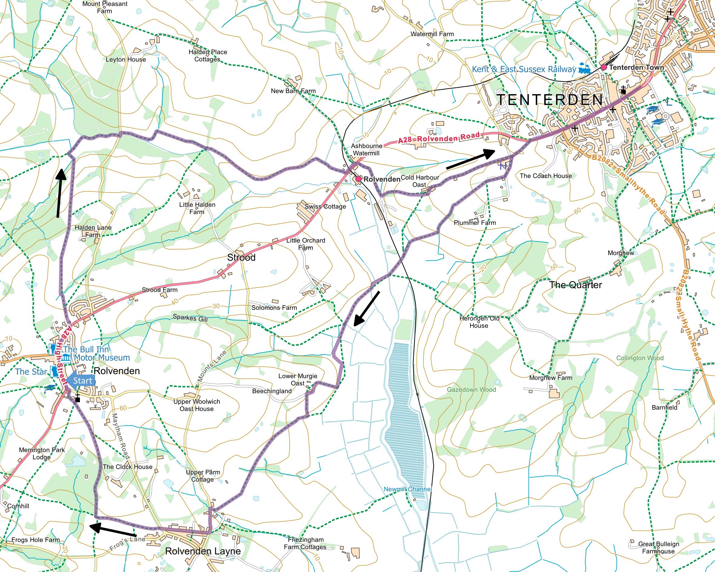
Click map to enlarge and click
again to enlarge further
Park in Rolvenden, in the main street or in a side
street near the church.
Go north up the main A28 towards Tenterden and soon
after Sparkeswood Avenue on the right take footpath AT36
on the left. Go up grassy track, through gate and
along path parallel to right hand edge of field.
When hedge turns right, carry straight on down field to
gate into narrow strip of woodland. Bear right
across another field to pass to right of jutting
woodland to gate and footbridge. Go straight
across next field to diagonally opposite corner.
Continue in roughly same direction aiming for gate 30
metres to left of end of narrow strip of woodland.
Continue still in same direction diagonally downhill
across field and pass through hedge at gap halfway along
left hand edge. Go down very short left hand edge
of field and turn right along bridleway to lane.
Turn left across stream then right along bottom of
field and half way up next side to gap on right.
Through gap head straight across middle of field towards
strip of woodland; keep to the right of this.
Follow the top edge of next field and part way along the
top of the next field go over stile on left.
Follow bottom edge of this field to gateway just past
oak tree then turn right along narrow field then a track
down to main road.
Turn left, cross railway and opposite former
watermill on left take concrete track over cattle grid
on right. Before reaching another cattle
grid and locked gates across track, go through gate on
left. Go uphill and keep right until you enter
next field then bear left to gate between farm
buildings. Pass stables, turn left then right past
converted oasthouse along track to lane and bear left up
to main road.
You can now turn right along main road into Tenterden
then return to this point to continue the walk. Go
back down lane and bear left past hospital entrance.
At fork in lane, take path between the two “prongs” into
hedge. Go through gate into field and turn right.
Pass a path that goes sharp left across field and take a
path bearing diagonally left across field to gate 100
metres to right of far corner. Turn left along
edge of next field and at corner go through gap into
next field and turn sharp right down right hand edge to
footbridge, left to another footbridge then across small
triangular field to railway crossing.
On far side follow obvious track towards wind
turbine. Bear right over ditch then along left
hand bank of ditch ahead. Just after left hand
bend, turn right across ditch and follow left hand bank
of smaller ditch (i.e. right hand edge of field) to
junction of four paths. Go straight ahead, cross
footbridge and rough ground to edge of cultivated field.
The path across the field may not be obvious.
You need to be about 100 metres left of ditch on your
right. Then head straight across cultivated field in a
southerly direction climbing gently and as you cross
brow of hill you should see gap in hedge ahead. On
far side turn right uphill along right hand edge of
field to buildings at Lower Murgie Oast. Bear left
along track and soon after sharp right hand bend go down
steps hidden in hedge on left.
Go slightly right of straight down field to hedge and
turn right. On entering next field bear left up
bank to gate on left and on far side turn right along
field edge. After 70 metres at post bear
diagonally left across field to gap in hedge (not
visible until you are over brow of hill) and across
corner of next field into narrow wood. Through
wood turn right to corner then follow right hand edge
field to top corner. Go through gap on right and
head diagonally across another field to join track in
corner. Turn right down track to lane.
Turn left to road junction then right along Frensham
Road through village of Rolvenden Layne to next road
junction. Bear right across Maytham Road to path.
Once in field, bear left to kissing gate and take path
between fences. At end of fenced in path go
straight forward along right hand edge of field and
through kissing gate at corner. After a few metres
go through another kissing gate on right and take path
through grounds of Great Maytham Hall.
On emerging again into the open, bear left across
meadow towards church. Looking to the left you can
see a water tower that was converted into a house and
featured on TV’s Grand Designs. Go through
churchyard back into Rolvenden village.
|
Points of Interest
Tenterden

Tenterden has a charm all of its
own. The
broad high street is lined with properties that bear
testimony to the town’s affluence from the wool trade.
The varied architectural styles blend well
together and display the full range of building
materials typical of the Weald – red brick and hanging
tiles reflecting the iron content of the Wealden clay
and white weatherboarding introduced when Scandinavian
timber imports became cheap.
The church in contrast is made from “Bethersden
marble”, actually a local freshwater limestone found
amongst the Wealden clay.
The church tower is very ornate, supporting the
legend that the tower caused the Goodwin Sands because
money intended for coastal defences was diverted instead
to building the tower.
In medieval times Tenterden was a
corporate member of the Cinque Ports although the
harbour itself was two miles to the south at Smallhythe
on the Rother estuary but long ago silted up.
Great Maytham Hall
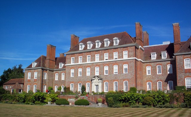
The present house was designed by
Edwin Lutyens and built in 1909.
Author Frances Hodgson Burnett lived in the
previous house on the site and the walled garden was
said to be inspiration for her book The Secret Garden.
The house is now converted into luxury flats.
The photograph was taken by
Stephen Nunney and is licensed for re-use under the
Creative Commons Licence.
Public Transport
Service R10 connects Cudham recreation ground with
Orpington Station via Green Street Green.
In addition to the walking routes on our web site we
have published three popular walking guides:
Guide to Tunbridge
Wells Circular Walk and other walks in the area
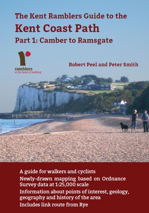
Guide to the
Kent Coast Path: Part 1, Camber to Ramsgate
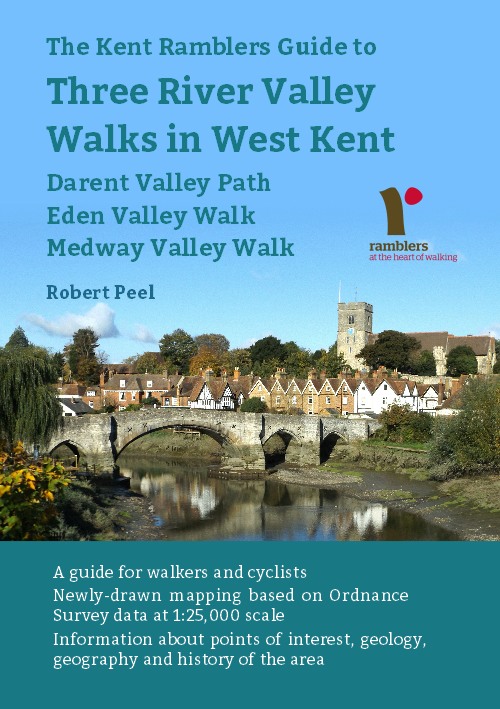
Guide to Three
River Valley Walks in West Kent: Darent Valley Path,
Eden Valley Walk and Medway Valley Walk
Please report any problems with this walk to
info@kentramblers.org.uk.
Ramblers' volunteers in Kent work tirelessly to
ensure that our paths are as well protected and
maintained as possible. Of course we also organise
led walks but most of our members are independent
walkers who simply want to support our footpath work.
Please
join us and become a supporter too. You need
us and we really need you.
Map contains Ordnance Survey data © Crown copyright
and database rights 2022. Some paths on map are based
on data provided by Kent County Council but do not
constitute legal evidence of the line of a right of way |